I’ve received a few emails, texts and phone calls about the Hawk fire in Reno. I’m safe.
Heather and I moved to the Reno basin about six years ago. I’ve mention living in the high desert from time to time and that is this area. It’s part of the larger Great Basin area of the North American Continent. It spans most of Nevada, all of Utah, plus parts of other nearby states. It’s defined as an area where rainfall never makes its way to an ocean. All the rain we get, we keep — all six inches of it every year. Most of the area is above about 4,000 ft above sea level and almost nothing grows here except sage brush, rabbit brush, grasses and some trees. Rock, sand, sagebrush and mountains is the landscape here.
Still we can get fires and when the light up, well just get out of the way. A fire in the brush here burns hot and fast. A thousand acres can burn before firefighters can get on scene. That is if there is a firefighter anywhere nearby. Not a lot of people live in Nevada outside the major metropolitan areas of Las Vegas and Reno/Sparks. There are a number of small towns and cities but 90% are in the two big metro areas.
And Nevada is a big state — the 7th largest in the US by area, 110,000 square miles. Just for the record and before anyone asks Las Vegas is 440 miles from my house, an eight hour drive. The last time I was there was 1968. I hear it’s changed some.
The national news picked up pictures of the Hawk in Reno fire sometime late Monday with a few dramatic photos from the first few hours of the fire (we even made the BBC). The fire start on Saturday morning about 11:15 am PDT on the Hawk Meadows trail near an upscale area in northwestern Reno known as Summerset. This a 55+ retirement community built by DelWeb about 10 to 15 years ago. I live on the other side of Reno about 20 miles away.
On Saturday the Weather Service posted, “Red Flag” warnings for increased fire risk due to high winds and low humidity. Sadly someone sparked a fire in the grass and sage brush just a mile or two from Summerset. I heard the first reports around 3:00 pm and at that point the fire covered 2,500 acres and was moving northeast over Peavine Peak through rural areas towards another populated area that we locally call the North Valleys which include Stead, Red Rock, Lemon Valley, Golden Valley, White Lake and Border Town just to name a few. All of this right on the Cal/Nev border with the Sierra forests just west of the fire.
By early evening the fire covered the about six miles over Peavine Peak and into houses. Winds that night were between 20 and 40 miles per hour with humidity around 15% turning a brush fire into a apocalyptic blow torch. Evacuation orders went out and by the time I was able to get good reports from the reporting agencies, the fire had spread to 15,000 acres with 42,000 people ordered to evacuate and 90,000 more under evacuation warnings or around 25% of the population of the Reno/Sparks Metro area. Heather and I counted at least 10 families that we knew of who were under some kind of evacuation or warning.
By Sunday morning things weren’t looking good except that the winds had stopped around 11:00 pm the night before and they had stopped forward progress of the fire. By the end of Sunday they had 10 aircraft and 1,000 personnel, firefighters, police, and National Guard, working the fire and had largely stopped forward progress of the flames. As you can imagine there was a lot of confusion, fear and anger about the situation. At church Heather and I took it upon ourselves to start a list of church members in the fire area and see who was safe and who still needed help. We came home with a list of 20 families in the evacuation areas and a list of 10 people willing to provide housing for then if needed. By early afternoon we’d made enough phone calls to assure ourselves that everyone was safely out of harm’s way staying with friends or family.
Yesterday the bad news was released that 47 homes and one business were destroyed in the fire with eight more damaged. Only seven people have been reported as injured and no fatalities have been discovered. The cause is listed as, “Human started.” Fire investigators are working on that so it’s not known if that’s arson, off-road vehicles, cigarettes or target shooters (all have been known to start fires here).
As of today, most of the evacuation orders have been lifted with a few thousand still out of their homes. The power company has restored most of the power in the area and fire command is now reporting that the fire is 85% contained. All this just as a new fire has been reported in the northwest corner of the county.
Sadly this is just part of life here. This is the fourth major fire in this area this year. It’s the second time we’ve had major evacuations. If you think that’s bad, we’ll it’s a change from the flash floods we had last month that damaged six homes about a mile from my house. Fun times here in the desert.
Still life goes on and in between checking evacuation maps I kept working on the greenhouse:
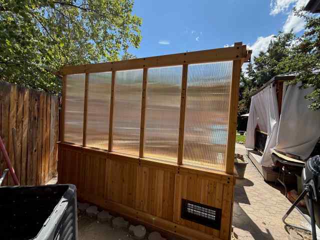
I installed windows and …
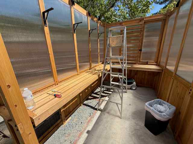
a bench for all the plants Heather is going to put in here. The ladder is there so I can put on the roof. You need a roof — keeps rain and burning embers out.
Well that’s it for this week. If you need me, I’ll be in the garage restocking our “go bags.”


Oh man. I’ve dealt with wildfires here in Southern CA and know how frightening and destructive they are. I’m glad you’re okay. Ooof. I feel for all those residents. But great progress on the greenhouse!
LikeLiked by 1 person
It’s strange to think you’d get this kind of fire here in grass and sage brush, but it happens.
LikeLiked by 1 person
LikeLiked by 1 person
So glad you and your church families are safe. Fire is something that is hard to outrun if you don’t leave when you are told to.
LikeLiked by 1 person
and this fire moved fast so many people had trouble getting out.
LikeLiked by 1 person
So horrible 😦
LikeLiked by 1 person
Glad you’re safe. So many intense fires this year.
LikeLiked by 1 person
Yes, a lot of them this year and it’s just going to get worse.
LikeLiked by 1 person
I’m glad you’re okay – any wildfire is terrifying, and it’s hard to fathom how explosively fast that one grew. Fingers crossed that the fire season ends soon for you. We’ve had a couple of “dress rehearsals” with our go-bags this summer; but fortunately we haven’t had to evacuate (yet). Fingers crossed for rain here, too.
And your greenhouse looks gorgeous! I’m sure it will be a pleasure to use. 🙂
LikeLiked by 1 person
We got some rain today so that should keep the fires down for awhile. The vegetation here is so dry most of the time that it can explode through hundreds of acres while you’re on the phone reporting. On my side of town we don’t have as much vegetation so we don’t get as many fires out here.
I’m loving this greenhouse project.
LikeLiked by 1 person
Glad to hear you guys did OK. it was so good of you, too, to watch out for others. Take care.
LikeLiked by 1 person
We have to look out for each other.
LikeLike
Living in CO for thirty years we have not-so-fond memories of fire impacts (and evacuations) like your Hawk. As you say it’s an inevitable, seasonal part of living in the high desert. We’re still trying to get comfortable with open burning down here in the South. People burn everything (instead of just taking things to the dump which their property taxes fund – go figure). They also love to leave these fires unmanned. Gets your heart a-pumping when you’ve lived in the West where the slightest change can mean completely out of control.
LikeLiked by 1 person
I get that — I’d have a hard time watching people just walk away from a fire.
LikeLiked by 1 person
So glad you both and others are safe. Life goes on.
LikeLiked by 1 person
Life has to continue.
LikeLiked by 1 person
Very glad you’re safe. There seem to be a ton of fires this year, all over the continent.
LikeLiked by 1 person
We’ve had four major ones in my area and a few small ones. It’s been a busy year for the firefighters.
LikeLiked by 1 person
Gosh! I’m thankful you’re safe!
LikeLiked by 1 person
It never affected us directly, just some of our friends.
LikeLiked by 1 person